See all Sydney suburb rankings · all lists · safest · for families · best value · young professionals · greenest · for runners · best coffee · public transport · wealthiest · most active
Condell Park
Ranked #197 of 422 Sydney suburbs for active. Every number below comes from open data — official crime statistics, ABS census and GPS activity traces — not opinion.
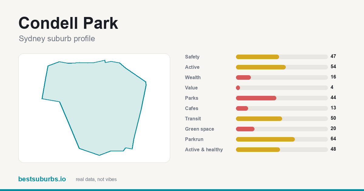
Condell Park suburb profile: score breakdown
Condell Park crime rate, rent, prices and other numbers
| Population | 13,066 |
| Area | 3.81 km² |
| Postcode | 2200 |
| Median household income | $1,636/wk |
| Median rent | $500/wk |
| Median house price (Jan–Mar 2026) | $1,608,000 (38 sales this quarter; up 2.1% YoY, up 47.0% QoQ; postcode 2200, not suburb-level) |
| Median unit price (Jan–Mar 2026) | $635,000 (85 sales this quarter; up 10.4% YoY, up 1.4% QoQ; postcode 2200, not suburb-level) |
| Crime rate | 37.7 incidents per 1,000 people — 48% of offences are against property, 52% against the person |
| Parks | 15 (0.65 ha per 1,000 people) |
| Schools (government data) | 2 — 1 primary, 1 secondary; nearest primary 0.39 km, secondary 0.82 km |
| Families score | 60/100 (safety 30 · schools 25 · parks per 1,000 15 · kinders 10 · price-for-size 10 · transit 10) |
| Within 400m of a park | 63.4% of the suburb |
| Cafés | 0 |
| Gyms & sport venues | 55 |
| Public transport stops | 81 (81 bus stops) |
| Nearest parkrun | Panania parkrun (2.67 km) |
| Schools nearby (OSM, not catchment zoning) | 3 schools in the suburb, plus 3 kindergartens — nearest is Condell Park Primary (0.36 km) |
Sale prices: NSW DCJ Rent and Sales Report, January - March 2026 quarter — © State of New South Wales (Department of Communities and Justice), Rent and Sales Report, CC BY 4.0; suburb-to-postcode mapping © GeoNames.org, CC BY 4.0. NSW publishes no free suburb-level sale medians, so this is the median for the suburb's POSTCODE (non-strata sales = houses, strata = units), which can span several suburbs. Low-volume figures rest on 30 or fewer sales in the quarter; postcodes with 10 or fewer sales are withheld by DCJ.
Who lives in Condell Park
Source: ABS Census 2021; sale prices NSW DCJ Rent and Sales Report, January - March 2026 quarter. We do not hold a suburb-level renter/owner split, families-with-children rate, born-overseas rate or dwelling-type breakdown for Condell Park — the fields above are everything the census data behind this site currently carries.
Common questions about Condell Park
What is the postcode for Condell Park?
The postcode for Condell Park, Sydney is 2200.
Is Condell Park a good suburb?
There is no single invented "overall" score here -- Condell Park is measured on 10 separate categories rather than blended into one number. Its strongest is active, ranking #197 of 422 Sydney suburbs, and it ranks in the top half of Sydney for 2 of the 10 categories measured here. The full breakdown is above.
Is Condell Park safe?
It is around the middle of the pack for Sydney, scoring 47/100 for safety and ranking #223 of 422 suburbs. Recorded offences run at 38 per 1,000 residents. That score is recorded offences per 1,000 residents from official crime statistics, as a percentile against every other suburb in the city.
Is Condell Park good for families?
Mixed, and the weak spot is green space. Here are the family measures we can compute — safety 47/100, parks 44/100 and green space 20/100, with a median age of 34. It has 2 schools in the suburb, with the nearest primary 0.4 km from its centre. School counts and distances feed the families score; catchment zoning and school results do not (we cannot publish those) — see our Sydney families ranking for the full method.
Is Condell Park expensive to live in?
The median house sale price was $1,608,000 in Jan–Mar 2026 (NSW DCJ Rent and Sales Report, postcode-level), up 2.1% YoY, up 47.0% QoQ. Median rent is $500 a week, and household income ranks #354 of 422 in Sydney. Against what the suburb offers, it scores 4/100 for value.
Does Condell Park have good public transport?
It scores 50/100 for transit, #212 of 422 in Sydney. That measures train, tram and bus access within the suburb boundary, weighted by mode.
Are there parks in Condell Park?
63% of the suburb is within walking distance of a park, at 0.7 hectares per 1,000 residents — 20/100 for green space.
Is Condell Park good for running?
The nearest parkrun is Panania parkrun, 2.7 km away, and GPS activity traces put it at 54/100 for how much walking, running and riding actually happens there.
Scores are percentiles against every other suburb in Sydney: 100 is the
best in the city, 50 is mid-table. Updated October 2026 (last updated 2026-10-12). Sources: open GPS activity traces,
official crime statistics, ABS census, OpenStreetMap.
About this data: every number on this page is computed from public sources — it is not an
opinion or a sponsored placement. See how we rank suburbs
for the full method.
← all 422 Sydney suburbs, with sliders